Latest News & Trending Topics
Western Sydney Airport Flight Paths: What You Need to Know
Construction of Western Sydney International Airport (Nancy-Bird Walton Airport), also often referred to as Badgerys Creek Airport, is well underway in NSW – with operations expected to launch by 2026.
The Federal Government has invested up to $5.3 billion in equity to make this airport a reality, with the airport planning to operate on a 24-hour basis to accommodate 10 million passengers from opening, and without any curfews.
A frequently asked question surrounding the new infrastructure, however, is whether any Western Sydney Airport flight paths have been finally determined by the Government. The short answer is ‘no’, and this article will explain in further detail about what we do currently know about the state of possible flight paths.
Western Sydney Airport: A Brief Overview
Before we get into detail about what possible flight paths will be flown, it’s important to have a basic background understanding about the new airport itself.
Open Date
The Airport’s expected open date will be in 2026. Construction of the airport started on 24 September 2018, after the Badgery’s Creek site was first designated by the Federal Government as the official airport site on 15 April 2014 (following decades of debate).
Airport Size
The site of Badgery’s Creek Airport is 1,780 hectares. It falls within the City of Liverpool’s Local Government Area in NSW, and was acquired by the Commonwealth of Australia from 1986 to 1991.
Location
Western Sydney Airport will be located approximately 44 kilometres west of Sydney’s Central Business District, and around 41 kilometres west of Sydney’s current airport, Kingsford Smith.
Transport
There will be multiple ways of travelling to and from the new Airport.
Road
The Government will build a new M12 motorway to access the airport as part of the Western Sydney Infrastructure Plan. It will run from the M7 (east) to the Northern Road (west), providing access to the airport.
Rail
A new Sydney Metro will be built to access the Airport via rail, and is planned to extend 23 kilometres with six new metro stations on it.
Bus
The Western Sydney Infrastructure Plan will also introduce new bus services providing direct links into key centres in Western Sydney. The business case is considering “rapid bus connections” in Campbelltown, Liverpool and Penrith.
Cost
The total Western Sydney Airport project will cost approximately $11 billion. This includes an Australian Government contribution of $60 million towards the Western Sydney North South Rail Link and $5.19 billion towards the Airport itself (including a $61 million Elizabeth Drive Overpass).
Curfews
Western Sydney International will operate on a 24-hour basis with no curfews.
Why is it being built?
According to the Airport’s 2016 Environmental Impact Statement (EIS), there is increasing demand for aviation in the Sydney area. The demand is not able to be fulfilled by existing airports’ limited capacity, principally that of Sydney’s Kingsford Smith Airport – which is subject to curfews and movement caps.
Expected jobs and growth
The airport is expected to both directly and indirectly create 28,000 jobs by 2031 and 48,000 jobs by 2041. This will include 6,450 in the retail sector, 5,600 in manufacturing and 5,600 in professional, technical and scientific services.
Western Sydney Airport Flight Path Update
As of May 2022, there are no confirmed Western Sydney Airport flight paths. The only paths released in the Airport’s 2016 EIS come with the disclaimer that they are “indicative only”.
Further specific details may be agreed to in due course. However, this information is not publicly available.
Flight paths ‘up in the air’ as the community considers the airport’s impact
The Western Weekender reported that final paths were still ‘up in the air’ as members of the local and surrounding community considered the airport’s impact. The topic is a consistent point of concern to the community due to the impact of aircraft noise.
According to one resident, the airport “has been in the planning stages for years”. With so many experts involved, he said, “it seems strange that they could not have come up with flight paths yet”.
Western Sydney Airport flight plans not released despite approval granted
There is no question that construction of the Airport has been approved, but years have passed without any final flight plans in place.
“Indicative” flight path designs were prepared by Airservices Australia, the organisation responsible for controlling air traffic across the country.
The primary consideration when designing them was air traffic management, and especially how any paths would interact with existing flights operating to and from Sydney Airport. The idea propounded was that all paths entering and leaving Western Sydney Airport would operate completely independently of Kingsford-Smith Airport.
Below are maps of indicative flight paths taken directly from the 2016 EIS, which show indicative paths at Stage 1 Development of Western Sydney Airport.
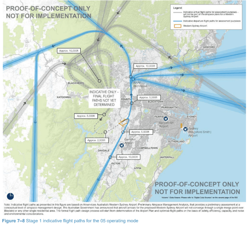
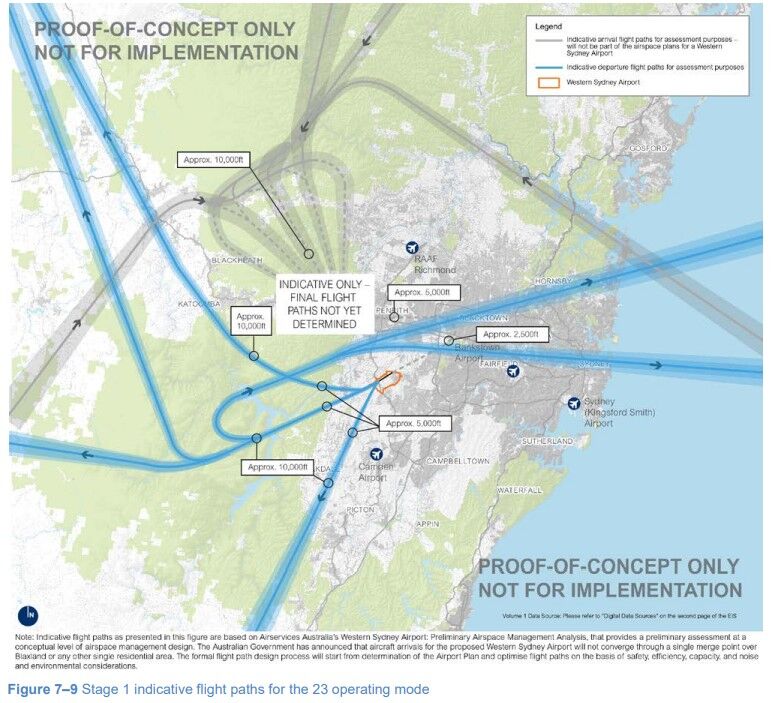
As can be seen, each map considers two different ‘operating modes’ (05 and 23), known as operating modes 05 and 23.
Operating Mode 05 involves all aircraft approaching the airport to land from the south-west and directed to take-off to the north-east, before redirecting towards their ultimate destination.
Operating Mode 23, by contrast, requires all aircraft to land at the airport from the north-east and be directed to take-off to the south-west, before redirecting towards their destination. These operating modes are expressed in the EIS as follows:
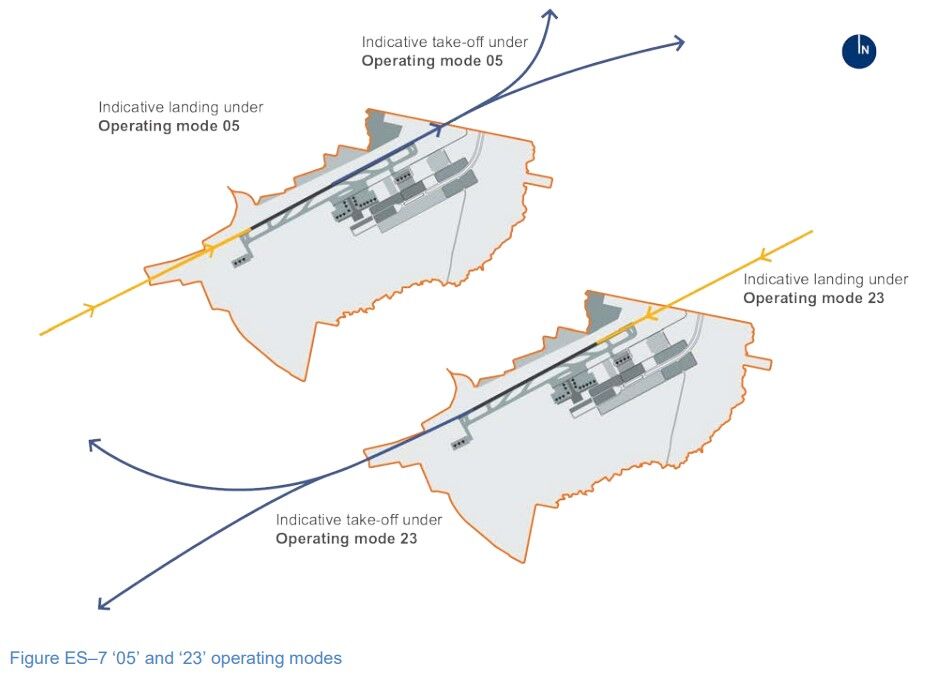
These are the two main ways that the single runway to be built at Western Sydney Airport will be able to be used.
In determining the arrival paths, Airservices Australia selected what is called the “Open-Closed hybrid system’ as the basis for developing them. This involves a combination of two different types of Standard Terminal Arrival Routes (STARs), which are routes that air traffic control establish to direct arriving aircraft to an airport. This includes:
- Open STARs, which aims to achieve arrival spafcing through allowing air traffic personnel to adjust aircraft speed and approach path using radar vectoring; and
- Closed STARs, which allows aircraft to use continuous descent profile with limited intervention from air traffic control.
The hybrid system combining these options are new, but no decision has been made about the final arrivals management system.
Airservices Australia’s design for departure paths reveal that the paths branch off to other paths at significantly distant locations (around 35 km to 45 km from Western Sydney Airport).
Originally, in October 2015, the Government did release a draft EIS which outlined proposed the same paths. However, this statement showed that flights approaching the airport were to reach a ‘merge point’ around 1,500 metres over Blaxland (in the Blue Mountains). The from that merge point would then require aircraft to turn southwest or southeast, prior to flying towards the Airport in Badgerys Creek via the northeast or the southwest. This merge point was eventually removed following backlash and community consultation.
Possible long-term flight paths
The 2016 Environmental Impact Statement also released what long-term indicative aircraft paths may look like, with a second runway expected to be required by around 2050.
Again, the maps are separated into operating mode 05 and operating mode 23:
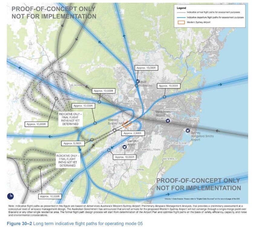
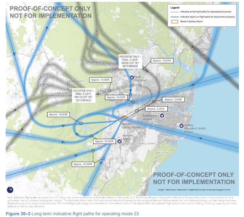
The analysis of Airservices Australia considered that, over the long term, parallel runways could achieve approximately 100 aircraft movements per hour (compared to Sydney Airport, which is capped from a regulatory standpoint at 80 per hour). However, a number of issues need to be considered before these parallel runway are built, including:
- any changes to the paths of Kingsford-Smith Airport;
- any changes to paths serving Bankstown Airport;
- aircraft noise considerations;
- the impact on tourist attractions such as the Blue Mountains World Heritage Area; and
- any issue arising from the restricted airspace area over the Defence Establishment Orchard Hills.
The Government has, however, announced that the construction of Nancy-Bird Walton Airport won’t have significant impact on the World Heritage Values of the Greater Blue Mountains World Heritage Area. This was a point of concern, given that the Blue Mountains has been included on the World Heritage List since 2000.
Despite no clear flight path, there are terminal designs
We have seen innovative design occurring on the site, with construction of a 3.7-kilometre runway underway.
A joint venture consisting of CPB Contractors and ACCIONA are in charge of the construction, with Western Sydney Airport’s CEO Simon Hickey saying the runway will be powered by cutting-edge technology that will minimise delays on the tarmac.
Mr Hickey also said that the airport will get aircraft to their gates and into the air “faster”, and will be able to operate safely in foggy conditions that would otherwise shut down the skies of Sydney.
Unfortunately, these benefits are still not impressing some communities – and that’s primarily because of the lack of confirmed flight paths. The airport is being called a “lose-lose situation” for the Blue Mountains, for example, given the flight paths are still being kept “secret”.
What suburbs will be affected by Badgerys Creek Airport?
The indicative flight paths reveal that the planes will descend to as low as 1,500 metres over a variety of suburbs in Western Sydney before landing. Suburbs that may be affected include:
- Badgerys Creek
- Orchard Hills
- Mt Vernon
- Kemps Creek
- Luddenham village
- Twin Creeks
- Erskine Park
- St Clair
- St Marys
The conclusions of the 2016 Environmental Impact Statement forecasts that the Airport’s “Prefer 05” operating strategy will a greater affect on existing residential areas than the “Prefer 23” strategy. The former is based on approaches and departures in a south-west to north-east direction, with the latter is based on the opposite direction. These include residents in suburbs to the north, with the Assessment specifically mentioning St Marys and Erskine Park.
The EIS specifically mentioned:
A Prefer 05 strategy is predicted to result in large parts of St Marys experiencing more than 20 aircraft noise events per night, on average above 60 dBA.
What suburbs are under the flight path in Sydney?
Currently, there are a number of suburbs under the flight path for aircraft that fly to and from Kingsford-Smith Airport in Botany Bay. This primarily includes suburbs in the inner west, including St Peters, Stanmore, Summer Hill, Petersham and Marrickville.
Currently, there are a number of suburbs under the flight path for aircraft that fly to and from Kingsford-Smith Airport in Botany Bay. This primarily includes suburbs in the inner west, including St Peters, Stanmore, Summer Hill, Petersham and Marrickville.
How do I find flight paths at the airport?
There are a number of resources you can use to locate flight paths at airports, including Western Sydney Airport once it’s been built, including:
• FlightStats, where you can track flights by airport. You’ll get an idea with this app what area may be louder than the other.
• FlightAware Flight Tracker. This is both a website and an app that shows flight routes and the number of times that an aircraft takes that path.
• Skyvector. This is a little more complicated, and requires actually looking at an aeronautical chart to determine current flight paths.
• FlightRadar24. This is a website and ap in full colour allowing you to see a map of flights as they fly in real time. We’ll outline a little more about this application below.
How do I find flight paths over my house?
All the above four resources are useful to achieve find flight paths over your house. FlightRadar24, for instance, is useful resource in the form of both a website and a mobile app you can use to find out if there are paths over your house. This is because this software is live aircraft tracking app, where you can follow air traffic anywhere in the world.
Learn more about airspace and construction at the new airport
If you’re interested in learning more about Western Australian International’s airspace and construction issues such as flight paths, then we recommend monitoring the airport’s website on a regular basis.
Please also get in touch with our team here at Avlaw Aviation Consulting if you’re wondering how the new infrastructure will affect you, especially if you’re deciding to build any property around the new airport. Australian airspace restrictions are important to consider prior to DA submissions, so it’s important you know what limits may exist with regards to building and crane heights early.
This blog was prepared based on info available as of November 2022. New details regarding flight paths have been released since and are discussed here: REVEALED: Western Sydney Airport Flight Paths [2024 Update]